AI Image Recognition Software for Public Spaces
Every day, teams working in public spaces strive to keep communities clean, safe, and liveable. Yet understanding what is really happening on the ground still often depends on manual inspections, experience, and fragmented information.
As skilled professionals become increasingly scarce, AI-powered image recognition helps organisations prioritise more effectively, respond faster, and gain greater control over the daily dynamics of public space operations. Rather than functioning as a standalone technology, it becomes part of a single information flow where image recognition, inspection data, historical operational data, and real-time insights come together. The result is clear, intuitive information that helps field professionals focus on the right priorities and carry out their work more effectively and efficiently.
Smarter prioritisation of maintenance activities
Reduce reliance on scarce expertise
Practical AI for field and office teams
Discover how Jewel Image Recognition can help your organisation manage public spaces more intelligently.
Challenges in Public Space Management
Prioritisation based on assumptions
Increasing reliance on scarce expertise
Reacting Instead of anticipating
Reports that don't lead to action
Weed management, litter, and side waste collection all depend on making the right decisions. Where should you intervene? How should the issue be addressed? And what priority should it have at that moment?
In practice, organisations often lack a complete and up-to-date view of what is happening in public spaces. Teams rely on scattered observations, manual inspections, and increasingly scarce expertise to prioritise their work. During peak periods, when pressure on resources is highest, maintaining quality and control becomes even more challenging.
That is why the need for a continuous and objective view of the public space is growing. Not to replace skilled professionals, but to support teams in making better operational decisions.
AI beeldherkenning in de openbare ruimte
Jewel ontwikkelt beeldherkenningsmodellen voor verschillende toepassingen binnen beheer van de openbare ruimte.
Onkruid op verharding
Krijg continu inzicht in locaties waar onkruidgroei toeneemt en kwaliteitseisen onder druk komen te staan. Dit helpt teams om slimmer te prioriteren tijdens piekperiodes in het groeiseizoen.
Modellen:
- Onkruid rondom obstakels
- Onkruid in de lijngoot
- Onkruid op oppervlaktegroei
Zwerfafval
Maak zwerfafval zichtbaar op grotere schaal en ondersteun teams bij het prioriteren van locaties waar beeldkwaliteit onder druk staat.
Model:
- Zwerfafval
Illegale dumping
Krijg sneller inzicht in illegale dumping in de openbare ruimte en ondersteun teams bij het gericht opvolgen van meldingen en risicolocaties.
Modellen:
- Witgoed
- Grofvuil
- Vuilniszakken
Ondergrondse containers
Signaleer bijplaatsingen sneller en voorkom dat locaties verder vervuilen doordat afval blijft liggen. Teams kunnen direct ingrijpen op locaties waar de situatie escaleert. (achter de hand houden)
Modellen:
- Grofvuil
- Witgoed
- Klein afval
- Staat van de container
- Beschadigingen
- Vervuiling
- Graffiti
AI Image Recognition for Street Cleansing and Grounds Maintenance
Jewel develops image recognition models for a wide range of public space management applications.These models help organisations gain continuous insight into the condition of their assets, identify locations that require attention, and make better operational decisions based on objective data from the field.
Weeds on pavement
Gain continuous insight into locations where weed growth is increasing and quality standards are coming under pressure. This helps teams prioritise more effectively during peak periods in the growing season.
Models:
- Weed Growth Around Obstacles
- Weed Growth in Gutters
- Surface Weed Growth
Litter
Make litter visible at scale and help teams prioritise locations where cleanliness standards and visual quality are under pressure.
Model:
- Litter Detection
From Inspection to Predictive Maintenance
Image recognition is about more than detection. The real value comes from turning insights from the public space into better operational decisions.
That is why Jewel combines image recognition, historical data, completed work, and manual inspections into a single continuous information flow. This creates a more complete and objective view of what is happening in the field, including locations that cameras cannot reach. As a result, teams can prioritise more effectively, maintain better control over quality, and respond faster to changing conditions.
An up-to-date view of the public space cannot be built from a single data source. Jewel combines AI-powered image recognition with historical work data, manual inspections, and other operational data sources.
This creates the most complete possible view of the area. By combining multiple sources, teams also gain visibility into locations that image recognition alone may miss, such as areas behind parked cars, alleyways, and rear access paths. The result is a more accurate understanding of conditions in the field and a stronger foundation for prioritisation and decision-making.
By bringing information from multiple sources together, organisations gain insight into where quality standards are under pressure and where action is needed. Teams receive more than individual reports; they gain a continuous operational view that reveals patterns, supports prioritisation, and enables better decision-making.
This supports a continuous improvement cycle of planning, execution, monitoring, and optimisation, helping teams maintain control and continuously improve the quality of public space management.
Insights are translated directly into actionable work for the field. Through the Jewel field app, professionals receive tasks as part of their daily operations.
Locations can be presented as specific tasks or as area-based priorities on a map. Using colour indicators such as red, orange, yellow, and green, teams can immediately see where attention is most urgently needed. This enables self-managing field teams to make better decisions, focus on the right priorities, and deploy their capacity where it has the greatest impact.
All completed work and observations are recorded in a single platform. This provides continuous operational control, greater transparency towards stakeholders, and deeper insight into how the public space evolves over time.
As a result, public space management shifts from simply responding to reports to continuously anticipating changing conditions in the field. Teams gain the information they need to make proactive decisions, improve service quality, and stay ahead of emerging issues.
How Does Jewel's Image Recognition Solution Work?
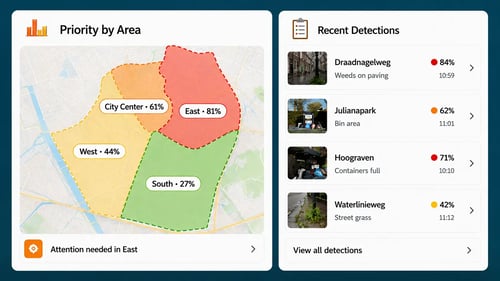
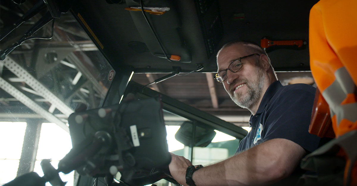
Continuous Insight from Daily Operations
Image recognition cameras are installed in field service vehicles. During regular routes, the system automatically captures anonymised images of the surrounding environment. This creates a continuous and objective view of the public space without requiring any additional effort from field teams.
The images are automatically sent to the Jewel platform, where they are combined with other relevant data sources for further analysis and follow-up. This provides large-scale visibility into what is happening in the field without adding workload to operational teams. The resulting insights are translated into clear priorities and actionable work, helping field professionals understand where attention is needed and how to respond most effectively.
AI-analyses
Within the Jewel platform, multiple detection models automatically analyse the collected images. The system can identify issues such as weeds on hard surfaces, weed growth around obstacles, litter, and side waste.
Each detection is visually highlighted and categorised, creating an up-to-date and objective overview of conditions in the public space without relying solely on individual observations or manual inspections. These insights are then translated into relevant information for every role within the organisation, from operational oversight and prioritisation in the office to clear tasks and actionable priorities for field professionals.
Turning Insights into Operational Decisions
Office-based supervisors and planners gain direct insight into priorities, detections, and current field conditions through the Jewel platform. Rather than treating image recognition as a collection of individual reports, the information is combined within a single central data stream. This creates a clear and up-to-date overview of the public space, helping teams understand where quality standards are under pressure and where attention is needed most.
These insights support field professionals in setting the right priorities and making better operational decisions. By translating complex information into intuitive guidance, teams can focus their efforts where they will have the greatest impact.
Autonomous Execution
Field teams can immediately see where attention is needed and which locations have the highest priority. Image recognition data is translated into clear and actionable information, enabling professionals in the field to respond faster and focus their efforts where they will have the greatest impact.
Because teams cannot be everywhere at once, this approach helps them deploy their capacity more effectively by focusing on locations that require attention most urgently. During execution, employees can record observations and document follow-up actions. Progress remains visible in real time within Jewel, providing continuous insight into the status of the area and the operational decisions being made.
Key Benefits of Jewel Image Recognition
Data translated into actionable information for field teams
Supports all public space management workflows
Optimised routes and smarter planning
Real-time visibility for full operational control
Intuitive apps designed for field teams
Better Office-to-Field Communication
Instant reporting and accountability
Paperless and more efficient workflows
Data-driven continuous improvement
FAQ - Jewel Image Recognition
Jewel Image Recognition is an AI-powered solution for public space management. By automatically analysing images captured during daily operations, the solution helps organisations gain faster insight into conditions and activities across the public space.
The real strength of Jewel lies not only in detecting situations, but in translating insights into operational decisions. By combining image recognition with historical work data, manual inspections, and the Jewel field app, organisations can prioritise more effectively, deploy resources more efficiently, and maintain greater control over day-to-day operations.
Image recognition does not capture 100% of the area, but it enables organisations to monitor a large portion of the public space continuously and at a high frequency during regular operational routes. When combined with historical work data and manual inspections, it provides a more complete and reliable view of what is happening in the field.
Within Jewel, this continuous data stream is translated into intuitive and actionable information for planners and field professionals. This helps teams prioritise more effectively, make better operational decisions, and maintain greater control over day-to-day operations.
Yes. Images are anonymised before they are analysed and stored, helping organisations comply with GDPR and other applicable privacy regulations.
The solution is designed with privacy, security, and responsible data use in mind. Jewel develops its image recognition technology with a strong focus on secure data processing, transparency, and the careful handling of information collected in public spaces. This allows organisations to benefit from AI-powered insights while maintaining compliance with privacy requirements and public trust.
AI helps teams identify emerging issues in public spaces at an earlier stage. By providing continuous insight into conditions such as weed growth, litter, or asset deterioration, organisations can take action before quality standards are exceeded or problems escalate.
This supports a more predictive and proactive approach to public space management, enabling teams to plan and prioritise work more effectively based on both current conditions and historical data. Over time, this helps organisations optimise resource allocation, maintain higher service levels, and stay ahead of potential issues before they become larger operational challenges.
Jewel combines image recognition with other data sources, such as historical work data and manual inspections, and translates this information into intuitive priorities and actionable insights for planners and field professionals.
By bringing recurring work and dynamic tasks together in a single workflow, Jewel supports the digital professional: a way of working in which technology and data help teams make faster, smarter, and better-informed decisions in their daily operations.
With real-time insight into progress and performance, organisations gain greater control over execution while improving collaboration, transparency, and operational efficiency.
Best-of-breed means using specialised software that excels at a specific function, rather than relying on a single system that tries to do everything. Jewel focuses on operational management and execution while integrating with other systems where needed.
This approach gives organisations greater flexibility, makes it easier to adopt new technologies, and ensures they always have access to the most effective tools for each part of their operation.
Why Choose for Jewel Software?
As dedicated grounds maintenance software, Jewel offers a digital platform that gives councils and contractors real-time insights — for example into maintenance tasks or budgets. The system’s integrations and dashboards are intuitive and easy to use. As a result, management becomes not only more efficient, but also more transparent for residents as well as for drivers and contractors. What we offer?
Efficient and digital processes
Less paperwork and administrative burden
Access to data anytime, anywhere
Supports the professional in the field
Sustainable and cost-saving solutions
Better collaboration between teams
Read More About Image Recognition

Weed Control on Hard Surfaces? How AI Helps You Through Growing Season
Weeds on hard surfaces do not grow at the same rate everywhere, nor are they asses…
Do You Have a Question?
Do you have a question about how Jewel can help your organisation? Schedule a meeting with one of our colleagues.
Stay informed!
Follow us on Linkedin →


-2.jpg?width=500&height=281&name=Comp%201%20(0%3B00%3B24%3B29)-2.jpg)
%20(1)-1.jpg?width=500&height=320&name=ChatGPT%20Image%20Jun%2016%2c%202026%2c%2010_16_29%20AM%20(1)%20(1)-1.jpg)

.webp?width=500&height=281&name=ChatGPT%20Image%20Jun%2016%2c%202026%2c%2010_29_56%20AM%20(1).webp)

